The Inner Harbor has long been a focal point of life in Baltimore. Beginning as a vital shipping port in Colonial times, the area has grown over the past three hundred years and become one of the Mid-Atlantic’s major economic engines. While the region has thrived, the harbor has not. Today, the Harbor’s waters rank as some of the most polluted in the Chesapeake Bay watershed.
In recent years, a coalition of concerned citizens from city government, civic organizations, business leaders, scientists, community activists, and schools has banded together to help restore the Harbor and created the Waterfront Partnership of Baltimore (WPB). The Partnership’s goal – a fishable and swimmable Harbor by 2020 – is a lofty one, but serves as a rallying cry for those wanting cleaner water.
Researchers from the University of Maryland Center for Environmental Science are working to develop the first Baltimore Harbor Report Card, a spatially explicit scientific assessment of ecosystem health. Based on the successful Chesapeake Bay report card developed by UMCES’ Integration and Application Network and EcoCheck, the Harbor report card will give local leaders a better understanding of the current quality of local waters and the surrounding watershed.
At the WPB’s “State of the Harbor” conference in February 2011, Dr. Heath Kelsey provided a glimpse into his team’s first analysis of the data, nearly all of which ranked as poor or very poor.
Most of the water quality parameters evaluated, including dissolved oxygen, nitrogen, phosphorus, water clarity, and chlorophyll a (the amount of algae in the water), scored below the ecological thresholds needed for healthy fish and habitats. Bacteria monitoring in the Inner Harbor indicated that for more than 80% of the time, it is not safe to swim. Trash continues to be collected at outfalls, along Fort McHenry, and by skimmer boats. While the benthic community for the entire Patapsco River was average, the Inner Harbor locations had very poor benthic index scores.
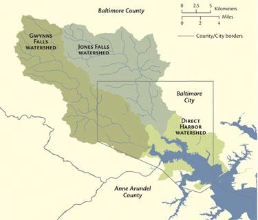
This is mirrored in the watershed. Benthic communities in Jones Falls and Gwynns Falls scored from Fair to Very Poor, indicating poor stream health. Data were provided by a variety of agencies, including Maryland Department of Natural Resources, Baltimore City, Baltimore County, and the Baltimore Waterkeeper. Water quality data stations were limited in the Inner Harbor, and plans to increase the numbers and locations of samples are being developed.
While the scientific analysis presented to those attending the conference was not a surprise, it serves as a starting point for change. With an improved understanding of the challenge facing the Partnership in upcoming years, they will be better able to prioritize their efforts and accelerate the cleanup of the Inner Harbor.
See Dr. Kelsey’s presentation for indicator-by-indicator details