What will my city’s climate feel like in 60 years?
Climate change has already begun to transform planet Earth, and over the next few decades these dramatic transformations are expected to accelerate in an ongoing response to greenhouse gas emissions.
You may have already experienced these changes where you live and may be wondering: What will climate of the future be like where I live? How hot will summers be? Will it still snow in winter? And perhaps How might things change course if we act to reduce emissions?
This web application helps to provide answers to these questions. We don’t have time machines so we can’t travel to the year 2080. However, we can think about places that are warmer and wetter (or drier) today than where we live. Perhaps you have traveled to such a place for a holiday or for work. We can ask: If climate continues to change, how much will my home town feel like this warmer and wetter (or drier) place?
To find places that have a climate today most similar to the expected future climate in your city, the Future Urban Climates web app uses some fancy number crunching for thousands of cities, towns, and suburbs across the globe to answer the question: If I wanted to experience the best example of what my city’s climate is expected to be like in the future, where should I go?
For example, if you happen to live in New York City, USA, you would need to travel to northern Mississippi to experience what New York is expected to feel like by 2080. Say hello to hot, really humid summers and goodbye to snow in winter. If you live in Shanghai, China, you would need to travel to northern Pakistan to experience what Shanghai’s climate could be like in 2080.
Because the answer to these questions depends on how climate is expected to change and the specific nature of those changes is uncertain, the app provides results for both high and reduced emissions scenarios, as well as for several different climate forecast models. You can map the best matches for your city for these different scenarios and models as well as map the similarity between your city’s future climate and present climates everywhere (based on the average of the five forecasts for each emission scenario).
An interesting, but not necessarily surprising finding is that there are no perfect matches. In other words, for no city is there an identical future and present-day climate. In fact, because of the magnitude of expected climate change, for many cities the “best” match is not all that similar, especially for cities closer to the equator. This means that many cities could experience a future climate unlike anything present on Earth today, especially if rates of greenhouse gas emissions are not reduced.
FIND OUT HOW YOUR CITY WILL FEEL IN 60 YEARS
How to use the Future Urban Climates app
Cities
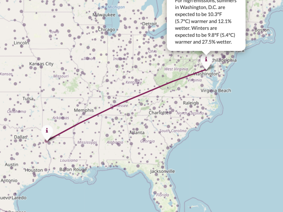
After selecting a city from the list on the left side of the page or by clicking on one of the cities highlighted with a purple circle on the map, you can map two kinds of information:
- A line from the selected city to the location with the most similar climate. This location will be the best match, but not a perfect match. The size of the circle gives a sense of how good of a match that location is, with larger circles indicating poorer matches.
- Or you can add a climate similarity surface to show not just the location of the most similar climate, but also how climate similarity to the selected city varies from place to place. If all locations have low similarity (in other words, all locations are a poor match to that city’s future climate), the climate similarity surface will be very small. Mumbai, India, is a good example where this is the case.
Emission levels
You can select one of two emission levels:
- Current high emissions
- Reduced emissions similar (but still higher) to those that we might expect under the Paris Climate Accord.
Further Reading:
This app includes updated analyses of those described in a 2019 paper published in Nature Communications.
Credits:
This app was created by Matt Fitzpatrick at the University of Maryland Center for Environmental Science - Appalachian Lab, with coding support provided by Teofil Nakov.