Using Landsat Time Series Data to Examine Patterns in Water Surface Temperature in the Chesapeake Bay
Overview
In highly productive estuaries like the Chesapeake Bay, water temperature plays an important role in regulating many biogeochemical and ecological processes. For example, eutrophication of coastal waters and associated anoxic dead zones is a worldwide problem caused by elevated nutrient inputs. But, these processes are also influenced by water temperature because dissolved oxygen decreases as water temperature increases. Therefore, tracking Water Surface Temperature (WST) change over time and understanding the contribution of climate change, runoff from impervious surfaces, and thermal effluent from industrial activities to temperature change is a grand challenge facing environmental science today.
In situ water temperature measurements made from piers, buoys, and mobile platforms have contributed to our understanding of the variation of water temperature over a range of temporal scales. However, this type of measurement is incapable of capturing spatial patterns in water surface temperature change in dynamic estuaries such as the Chesapeake Bay. Therefore, we used a dense stack of Landsat TM/ETM+ thermal imagery organized by day of year of acquisition to produce a climatology of water temperature in 5-year increments between 1983 and 2012. From this analysis, we calculate annual trends in WST in the Chesapeake Bay for the entire by surface north of the Potomac River. We found that on average WST has increased at a rate of 0.67 degrees C per decade since 1985. Once combined with information on urban development and industrial activities on land, we expect these spatially continuous data to contribute to our understanding of how trends in WST might relate to urbanization, thermal pollution, as well as to trends in air temperature due to global climate change.
Methods
The Chesapeake Bay is one of the largest and most productive estuaries in the world, supporting both an important fishery and recreational opportunities. Since 1975, urban land cover has increased by more than 100% in portions of the Piedmont and Coastal Plain adjacent to the Bay, which has influenced a variety of physical, chemical, and biological aspects of water quality. Over the same period, global climate change has included an increase in air temperature of over 0.5 C, with expected impacts to water temperature in the Bay.
A total of 196 images from Landsat Thematic Mapper (TM) and Enhanced Thematic Mapper Plus (ETM+) that covered the northern two-thirds of the Bay and all of the Bay in Maryland were acquired from the United States Geological Survey (USGS). Using the 10um thermal infrared channel, we corrected for atmospheric effects and generated WST maps from each image. These maps were organized by day of year to generate a WST climatology (a function describing the annual trajectory of WST including minimum and maximum temperatures) at 5-year increments between 1985 and 2012. The mean WST calculated from each climatology was evaluated over time and against air temperature measured at weather stations surrounding the Bay.
To validate the Landsat-based WST observations and the quality of our atmospheric correction, we compiled concurrently-collected in situ water temperature observations from the Patuxent River near Solomons, MD.
Results
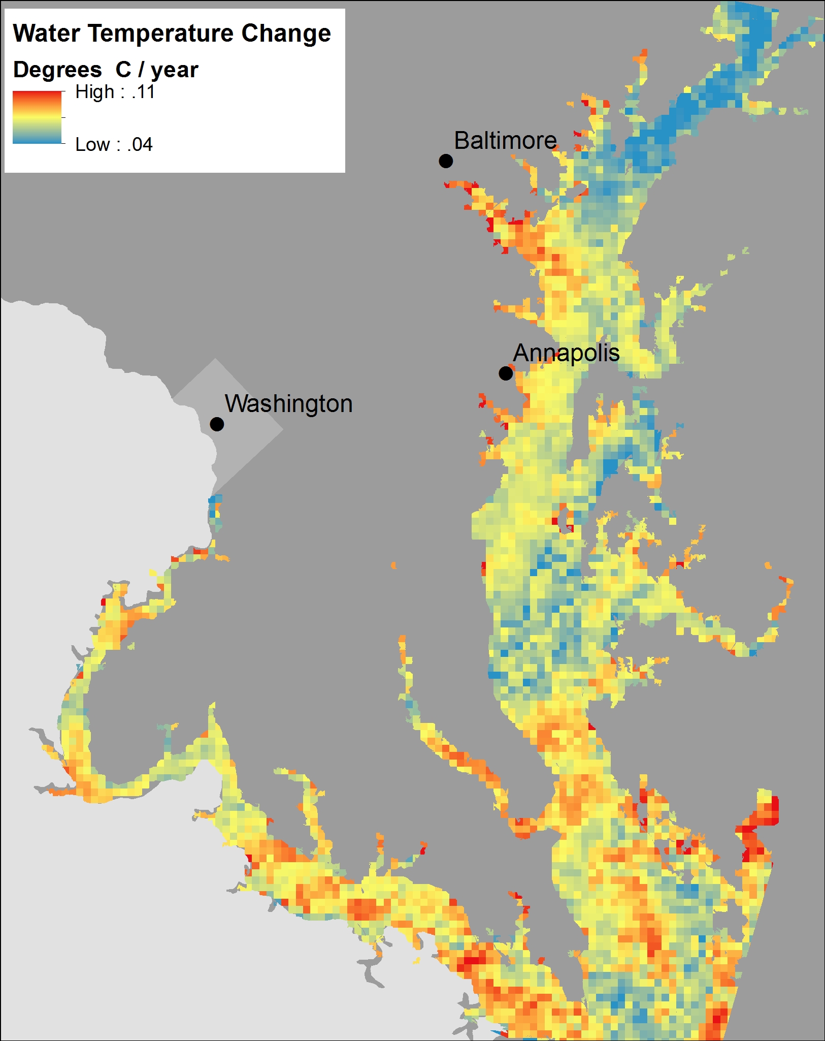
Trends of increasing water surface temperature were observed for more than 92% of the Bay. Our results exhibit broad scale patterns in WST, such as water surface climatological differences between the main stem of the Bay and its tributaries. The trend in water temperature increase was weakest at the top of the Bay near its confluence with the Susquehanna River. The trend of increasing water temperature over time strengthened towards the main stem of the Bay, where there is a greater influence of oceanic water. The spatial patterns also show locally more rapid water temperature warming in the Patapsco, Patuxent, and Potomac River estuaries, suggesting that these western tributaries are overall warming faster than the eastern tributaries and portions of the main stem of the Bay. The results also suggest the influence of urbanization and industrialization, such as increases in watershed impervious surfaces and thermal effluent from power plants.
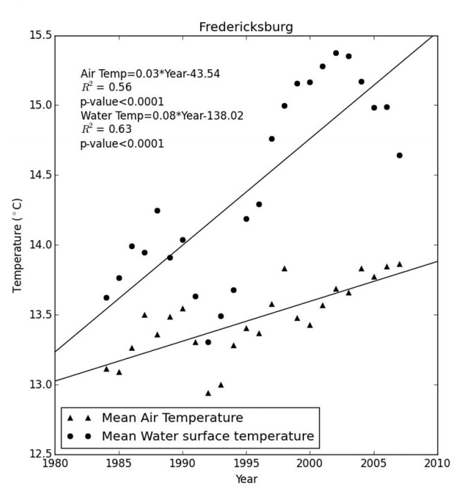
Results also demonstrated that water temperature has been increasing more rapidly than air temperature in some areas, particularly in the main stem of the Bay and in the Potomac estuary. Here, the data show that water temperature has increased more rapidly than air temperature. Therefore, the increasing trends in WST can only be partially explained by increasing air temperatures. The observed spatial patterns support a mix of drivers including, urbanization and power generation from human activities in the tributaries, as well as the influence of ocean water temperature, particularly in the main stem of the Bay.
Our results demonstrate that there is a detectable impact of global change on the Chesapeake Bay in the form of an increase in water temperature that can only partially be explained by increasing air temperatures. Increasing water temperature in the Chesapeake Bay has previously been studied and described using point measurements. The work described here, extends this understanding and contributes a comprehensive treatment of the spatial dimension. With satellite imaging, we can monitor the entire bay at once, thus identifying hot spots and calculating unbiased trends averaged over the entire bay surface. These data are ideal for the next step of linking land-based changes such as urbanization to surface water temperature change.
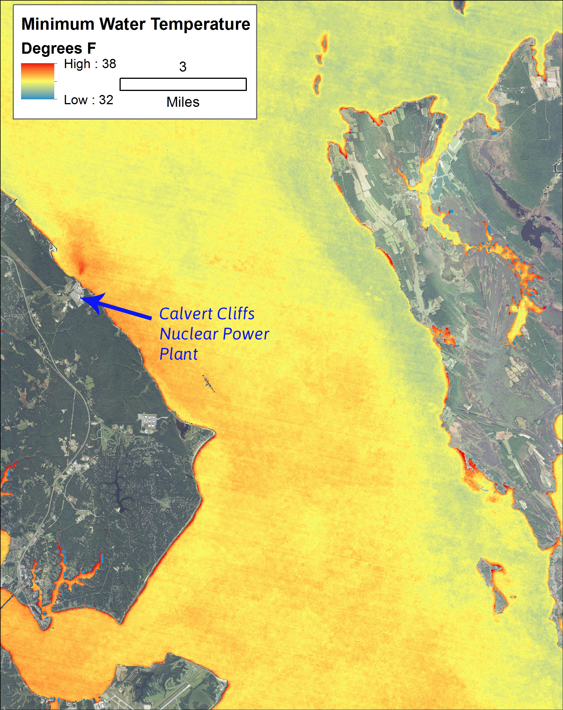
We studied the impact on WST of eight power plants along the shoreline of the Chesapeake Bay that use Bay water for cooling. A clear gradient with distance was found at most plants like the one shown below near Calvert Cliffs in sourthern Maryland. Water closest to the facility exhibits an elevated water temperature relative to water more distant from the facility: