Ongoing Indonesian Research by Dr. Mark Cochrane
Healing Maryland’s Forests with Fire
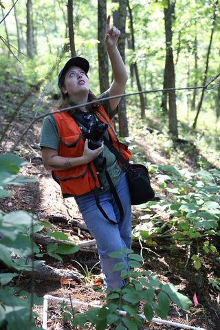 Decades of fire suppression and passive management in Maryland’s mountainous forests have significantly changed their natural fire regimes, resulting in lost biodiversity and increased risk of severe wildfires. Appalachian forest restoration requires prescribed fire or surrogate treatments such as forest thinning, herbicide application, and duff removal. Conservation managers are consistently asked to improve restoration results with fewer resources, so efficient forest management methods are needed. Holistic comparisons of various active management treatments will be informative of the most efficient pathways to restore mesic ecosystems in Maryland’s forests.
Disturbance regimes maintain mosaic patterns of different ecosystem structures and ages which promotes ecosystem resilience to varying stresses. Undisturbed ecosystems become increasingly homogenous and favor sensitive species that are strongly impacted when disturbances occur. More common in the western Unites States, prescribed burning has only recently been applied in eastern forests to mitigate potential wildfire impacts and promote restoration. Such fires are carefully managed to reduce the likelihood of widespread burning, protect late-successional trees, create mosaic landscapes, and promote understory growth.
Dense canopy layers also hide the understory layer of forested ecosystems from remote sensing technology that would otherwise be used to quantify herbaceous community composition in these ecosystems. The current state of the understory layer is extensively altered from historical norms but has not yet been quantified at landscape levels, making it difficult to examine responses to prescribed burning and fire surrogate treatments.
Understory plants contribute to nutrient cycling, provide food and habitat for wildlife, and increase overall biodiversity in forest ecosystems. We are working to develop a model that can predict understory health and composition using remotely sensed canopy imagery to minimize the time and effort required to study this important component of forest ecosystems.
We expect that the changes in canopy cover and dominant tree species have led to substantial shifts in understory community composition across the mid-latitude Appalachian region. We also expect that prescribed burning regimes will be effective in promoting mesic species regeneration and understory health. To examine these hypotheses, we will quantify the species composition, herbaceous health, and light attenuation at sites under different treatment protocols.
This study will advance scientific knowledge about the community composition of herbaceous plants across Maryland’s forests and how they will respond after fire treatments compared to passive management and traditional timber stand improvement methods. By reintroducing the region’s natural disturbance regimes, we can promote overall resilience and biodiversity, manage invasive species, and better understand the herbaceous layer’s role in maintaining healthy ecosystems.
Characterizing and monitoring changing fire regime and the risks of extreme wildfire events in the United States using biophysical models and satellite observations
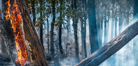
Wildfires in the United States continue to increase in both scale and impact, highlighting the urgent need for improved monitoring and management strategies. Remote sensing technologies, particularly satellite-based thermal observations and vegetation indices provide critical tools for understanding and monitoring the changing role and regimes of fire in the Earth system.
To characterize and monitor shifting fire patterns and Regional Extreme Wildfire Events (REWEs), this project is structured around five fundamental research questions 1) How can REWEs be conceptually and quantitatively defined? 2) What are the major biophysical drivers of REWEs? 3) How have biophysical conditions changed in recent decades? 4) What are the implications of these changes for smoke emissions? 5)Which remote sensing and ground-based resources can be combined and applied to monitor the development of REWEs under near-real-time conditions?
Funded by the National Aeronautics and Space Administration (NASA), this project is being conducted in collaboration with scientists at the U.S. Forest Service (USFS) Fire Science Laboratory and South Dakota State University (SDSU). The team is developing an integrated system that incorporates satellite observations of fire, smoke, and land-cover traits with ancillary datasets on land/snow cover, fuels, terrain, fire perimeters, long-term weather records, and eco-physiological models. Data sources include multiple Earth observation missions such as: MODIS (Moderate Resolution Imaging Spectroradiometer), VIIRS (Visible Infrared Imaging Radiometer Suite), ECOSTRESS (Ecosystem Spaceborne Thermal Radiometer Experiment on Space Station), GEDI (Global Ecosystem Dynamics Investigation), GOES (Geostationary Operational Environmental Satellite), MTBS (Monitoring Trends in Burn Severity), GLDAS (Global Land Data Assimilation System).
These datasets will be used to create an initial annual record of REWEs, enabling quantification of fire characteristics and associated environmental conditions. To harmonize spatiotemporal data, the project will leverage the H3 hierarchical geospatial indexing system, providing multiscale analyses that link REWEs to their underlying biophysical drivers within impacted ecosystems and communities. Machine learning approaches will also be tested to identify regionally consistent patterns of increased fire activity during periods of extreme weather.
The project will also produce maps of Regional Extreme Wildfire Potential (REWP) during fire seasons, enabling assessments of the total area of regions that could be vulnerable to wildfires under similar weather conditions. To investigate canopy seasonality effects on microclimate conditions, modeled evapotranspiration (ET) estimates from eco-physiological models will be compared against mapped ET derived from ECOSTRESS observations. Additionally, the team will calculate ecoregion- and landscape-specific emission coefficients (Ce) to estimate hourly and daily smoke emissions from wildfires across the United States.
Ultimately, this research aims to generate spatial maps of the Regional Extreme Wildfire Potential Index (REWPI) across the United States to identify areas most at risk of extreme wildfire events. By integrating remote sensing observations with geospatial analyses, the project will provide quantitative insights into land surface temperature, vegetation stress, and evapotranspiration patterns associated with wildfire risk. The resulting products are intended to support data-driven fire management strategies and enhance regional preparedness and resilience.
Monitoring forest carbon dynamics in response to disturbances in the southwestern Amazon
Fire Scene Evaluation Manual 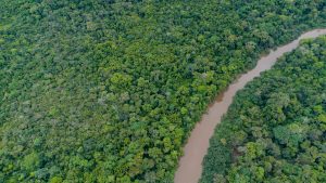 Amazonian forests harbor 25% of global terrestrial biodiversity and contain one of the planet’s largest stocks of biomass carbon stocks. They also play a critical role in regional and global climate systems. In recent years, frequent drought events and land use intensification in the region threaten these forest ecosystems. In the past two decades, Amazonia has experienced extreme drought nearly every five years and these events have caused extensive tree mortality and large-scale forest fires across the region. An extensive network of protected areas has been highly effective in avoiding deforestation and reducing carbon emissions during recent decades. Public protected areas in the Brazilian Amazon hold nearly half of total aboveground carbon. Remote sensing plays a crucial role in the monitoring of forest ecosystems in the Amazon. Remote sensing products provide information on the occurrence, extent and intensity of forest disturbances in terms of different spatial and time scales using optical/radar satellite systems.
In collaboration with institutions like Federal University of Acre (UFAC), Embrapa Acre, Amazon Conservation (ACCA), National Service for Industrial Training (SENAI), Forest Service of Peru, this project is providing stakeholders with new forest structure information, such as canopy height (CH) and above carbon density (ACD) that directly indicate carbon dynamics and related uncertainty that are derived from NASA’s spaceborne lidar (GEDI) dataset and other remotely sensed data for the southwestern Amazon (Acre in Brazil, Madre de Dios in Peru). The products derived from the project are being used to answer two main questions: Q1) How do forest disturbances (deforestation, fire, drought and fragmentation) impact carbon dynamics (loss and sequestration) in the southwestern Amazon? and Q2) How are carbon dynamics different inside and outside protected areas of different conservation unit types (Indigenous Territories, National Parks, National Forests, Sustainable Forests, State Protected Areas).
With this combined approach, the project seeks to advance scientific understanding of how climate stressors and land-use pressures are reshaping carbon dynamics in the Amazon. The outcomes will directly inform conservation strategies, improve carbon accounting frameworks, and provide actionable data for policymakers and local communities working to safeguard one of Earth’s most vital ecosystems.
Synthesis Study of Land Cover, Land Use, and Demographic Change under Multi-Dimensional Developments and Climate Pressures in Southeast Asia
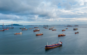
 Southeast Asia is undergoing profound transformations in land cover, land use, and demographic structures, all of which interact in increasingly complex ways with intensifying climate pressures. Rapid urbanization, agricultural expansion, deforestation, coastal development, and infrastructure growth are reshaping physical landscapes, while population growth, migration, and socio-economic transitions are altering the human dimensions of land systems. These coupled processes are further compounded by climate factors including rising temperatures, altered precipitation regimes, and sea-level rise which collectively drive feedbacks with far-reaching implications for ecosystems, food security, regional economies, and human well-being.
This project addresses a central scientific question: how do land cover (LC), land use (LU), and demographic (DG) systems evolve and interact under the combined influences of multi-dimensional development pathways and climate pressures in this highly dynamic and vulnerable region? To answer this, we integrate multi-scale satellite observations, demographic and socio-economic records, and climate datasets into a synthesis framework that systematically characterizes drivers, trajectories, and impacts of these changes.
The research is grounded in two guiding hypotheses. First, we hypothesize that in regions undergoing rapid transformation, physical–human feedback processes are amplified by urbanization, agricultural conversion, and climate stressors, rendering LC, LU, and DG processes non-stationary and producing unprecedented impacts that cannot be reliably predicted from past observable trends. These “hotspot” regions, characterized by abrupt and non-linear change, require multi-scenario assessments to guide adaptive policy development. In contrast, we hypothesize that in transitional areas experiencing gradual shifts, trajectories of LC, LU, and DG can be more directly linked to continuous environmental and socio-demographic trends, allowing historical references to serve as useful baselines for anticipating and planning future outcomes.
Over a three-year period, the project is structured around three interlinked objectives: (1) capturing physical-dimension features of LC and LU through satellite-derived products, field observations, and ancillary surface networks; (2) characterizing human-dimension features of socio-economic systems, including land consumption and conversion, biophysical alterations such as deforestation or restoration, and climate-linked environmental impacts such as greenhouse gas emissions and sea-level rise; and (3) synthesizing these physical and human dimensions into an integrative framework that identifies interactions, feedbacks, and emergent vulnerabilities.
By synthesizing these perspectives, this project seeks to generate a comprehensive, data-driven understanding of how land systems in Southeast Asia are being reshaped under multi-dimensional pressures. The outcomes will not only advance scientific knowledge of coupled human–environment systems, but will also provide actionable insights to guide sustainable land management, inform regional planning, and support the development of evidence-based policy frameworks that enhance resilience in the face of accelerating socio-economic and environmental change.
Continuation and expansion to a national-scale of the “Filling a critical gap in Indonesia’s national carbon monitoring, reporting, and verification capabilities for supporting REDD+ activities
Incorporating, quantifying and locating fire emissions from within tropical peat swamp forests
 Indonesia ranks as the 3rd largest CO2eq emitting nation, largely due to episodic uncontrolled fires within drained peat-swamp forests. Our original work (NNX13AP46G) set out to 1) provide extensive field investigation of land cover, hydrologic, fuel and fire dynamics in a 120,000 ha REDD+ project in Central Kalimantan; 2) Collect a new Lidar dataset to complement our existing 2007 and 2011 coverages; 3) Conduct groundbreaking detailed emissions field sampling of smoldering in-situ peat fires; and 4) Generate a fully parameterized and validated annual emissions model for the study region in support of its REDD+ project. Despite extensive bureaucratic and logistical challenges and delays inherent in working in Indonesia, objectives 1-3 have now been completed and the modeling efforts are ongoing with all necessary data now in hand as we complete the original project time period. However, our recent unprecedented emission findings (Stockwell et al. 2016), gained in situ during the height of the 2015 El Niño, have documented substantial differences between the actual regional peat fire emissions and existing emission factors, indicating regional Indonesian carbon equivalent emissions (100 year) may have been 19% less than current IPCC-based emission factor estimates. The IPCC emission factors are derived from one lab study burning peat from Sumatra (Christian et al. 2003) and considerable variation in emissions may exist between peat fires of Indonesia’s three major peat formations highlighting the need for the additional field emissions measurements we intend to carry out in the continuation of the project proposed here.
This work is expanding to a national level, our successful regional (Kalimantan) CMS project (NNX13AP46G), to better advance Indonesia’s Monitoring, Reporting and Verification (MRV) capabilities for peatland carbon emissions and support nationwide Reducing Emissions from Deforestation and Forest Degradation (REDD) efforts. We will implement our standardized field-based analyses of fuels, hydrology, peat burning characteristics and fire emissions, developed from our ongoing work in a 120,000 ha REDD+ project, to regionally parameterize our peatland emissions model for all of Indonesia’s major peatland areas by including three new locations, Riau and Jambi (Sumatra) and Western Papua (Papua), for inclusion within the Indonesian National Carbon Accounting System (INCAS). We will conduct on-site whole air sampling of natural peat smoke plumes in situ for precise measurement of non-reactive greenhouse gases, collect peat samples just in front of these active peat fires, and burn the samples in the US while measuring aerosol mass and optical properties and reactive gases. This will create comprehensive and pertinent emissions factors (EFs) for each study region that will be critically important for assessing health impacts and total global warming potential (GWP) of these emissions. Remotely sensed land cover/change (Landsat) and surface fire ignition timing and locations (MODIS) provide spatial and temporal drivers for the modelled emissions that will now be validated/constrained at a national level using biomass burning emissions estimations derived from Visible/Infrared Imager and Radiometer Suite (VIIRS) on board the Suomi National Polar-orbiting Partnership (NPP) satellite and the new Japanese Geostationary Meteorological Satellite (Himawari-8). Multiple lidar datasets (2014, 2011, 2007) for Kalimantan are being used to quantify model accuracy, and new work will be undertaken to quantify uncertainty in our most recent lidar-based digital terrain model (DTM), further improving assessments of modelling errors.
Download Fire Scene Evaluation Manual
Former Projects
Land-use transitions in Indonesian peatlands
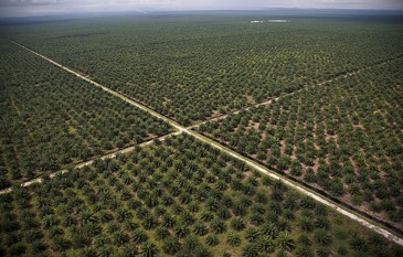
Indonesia’s tropical peatlands are essential for stabilizing global climate and conserving biodiversity. These peatlands cover an estimated 200,000 km2 , are biodiversity hotspots, and comprise a 57 Gt carbon reservoir. In recent years, these forested ecosystems have been rapidly degraded through unsustainable logging, drainage, conversion to agriculture and wildfire, leaving only 6% of peatlands unaffected by development. Due to rapid expansion and poor predictability, smallholder oil palm plantations are of particular interest. Indonesia’s oil palm has expanded from 70,000 ha in 1961 to 11.8 million ha in 2016, due to strong global demand for vegetable oil and biofuel. It is now the largest producer in the world. Smallholder farmers manage half the oil palm area in Indonesia, with a greater expansion rate (11%) than large-scale plantations (5%). The economic and policy forces driving oil palm expansion are evolving, but include both local and global factors.
The key objectives of this proposal are to understand historical and projected impacts of smallholder oil palm agriculture on Indonesian tropical peatlands and related impacts on aspects of landscape sustainability. To achieve these objectives, we plan to monitor and characterize the land-use and land-cover changes (LCLUC) in this landscape, to identify major drivers and impacts of those changes, and to use development and conservation scenarios to estimate likely landscape outcomes. The project would employ recently developed techniques to perform continuous change detection from dense stacks of medium resolution remote sensing data (e.g., Landsat and Sentinel). Resulting time series of forest canopy disturbance will be used in conjunction with LiDAR (airborne and NASA Global Ecosystem Dynamics Investigation data), to generate maps of canopy height in existing oil palm agriculture. Based on these products and spatial analysis, we will characterize land use transitions in the following categories from 2000 to present: (1) transition from peat forest to smallholding oil palm; (2) transition from other land uses (e.g., abandoned land) to smallholding oil palm; (3) transition from smallholding oil palm to large industrial estates. The impact of land use transitions will be assessed across a wide range of parameters, including environmental parameters such as carbon emissions, nitrogen loading, and forest cover loss, but also economic factors such as profitability and employment. We will develop statistical models to identify key drivers for each transition. Proposed drivers to evaluate include vegetation type, fire frequency, peat depth, climate conditions, oil palm processing infrastructure, market prices, and demographic characteristics of the labor population. These drivers and ecological impacts will be evaluated synthetically in a coupled assessment model that will be used to develop a decision-support tool capable of projecting future LCLUC transitions and their impacts for potential market, policy, disturbance, and climate scenarios.
This research is directly responsive to the LCLUC call for proposals addressing Land-Use Transitions in Asia, specifically focusing on the critical, but poorly understood smallholder land use dynamics surrounding oil palm expansion in Indonesian peatlands. We will make effective use of NASA observing systems (Landsat and GEDI observations) to refine and expand existing techniques for estimating canopy height across landscapes. For oil palm, this relates directly to age, maturity and likely rotation periods. Our remote sensing products, together with ancillary inputs on socioeconomic drivers of land transitions, will allow us to assess the landscape impact of agricultural production, develop land use transition models, and provide new understanding of how future LCLUC transitions will affect this dynamic and important coupled human-environmental system.
Effectiveness and monitoring of large-scale carbon-loss mitigation activities in Indonesia’s peatlands
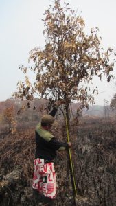
Indonesia is engaged in, arguably, the planet’s largest carbon-flux mitigation project. Through its Peatland Restoration Agency (BRG) they are blocking drainage canals with the objective of peatland restoration (“rewetting, revegetation and revitalization”) for 2.5 million ha of drained and degraded peatlands by 2020. Furthermore, the Ministry of Environment and Forestry has plans for restoring another ~5 million ha in the coming years. Reducing carbon emissions from Indonesia’s tropical converted peatlands, where frequent wildfires have become a globally-significant side-effect (84% of Southeast Asia’s carbon emissions), is essential for stabilizing global climate. Indonesia has unilaterally committed to reduceing its GHG emissions by 29%. However, Indonesia has yet to develop a methodology for monitoring and evaluating the effectiveness at reducing GHG emissions from these peatland restoration projects.
We plan to work with our stakeholders, BRG and FAO, to assess the effects of ongoing mitigation projects upon landscape hydrology, fire occurrence and behavior, and vegetation regrowth, which all impact carbon fluxes. We will accomplish this by building upon our established research infrastructure, with hundreds of established dipwells (hydrology), long term vegetation plots, and years of applying common methods for assessing fire behavior and carbon emissions at large research sites we maintain in Central Kalimantan (Indonesian Borneo), Riau and Jambi Provinces (Sumatra).
We will work with FAO to use our extensive field data (space and time), to calibrate the PRIMS Soil Moisture product. By relating PRIMS responses to water table depths, vegetation cover, distance to canals and frequency and time since disturbance, we will define the uncertainties of the PRIMS soil moisture estimates (Sentinel 1) as functions of these landscape attributes. We will subsequently validate the PRIMS products by verifying its accuracy when applied in Riau and Jambi, our other research sites that also contain ongoing BRG mitigation activities. We will also build a hydrologic model of the Mawas site (Kalimantan) to ascertain if canal blocking is only raising water levels, or if it is also changing drainage properties of the underlying peat. By detecting fires (MODIS/VIIRS), monitoring their behavior and peat consumption in the field, mapping their extent (Landsat/Sentinel 2), and evaluating changes in the particle emissions in smoke plumes (VIIRS), we will quantify changes in fire-related emissions from the mitigation activities. Similarly, by monitoring any changes in growth or composition within our vegetation plots, we will assess if the mitigation efforts are resulting in apparent restoration of degraded forests. We will also test the planned FAO PRIMS Subsidence product against our long term data series of well distributed subsidence plots to calibrate its outputs, compare it with GEDI lidar points (if available) to assess if discernible changes in peat height loss rates exist within and outside mitigation areas. These combined activities enable us to produce a comprehensive evaluation of if, where and how BRG mitigation activities are effecting carbon fluxes, while developing tools that will enhance our prototype CMS for tropical peatlands.
This work uses many satellite products to produce enhance CMS capabilities that are critical to assessing near-to-mid term carbon fluxes and changes to those fluxes caused by peatland restoration efforts. We are also advancing our stakeholder’s interests by helping BRG to assess effectiveness of mitigation projects, and helping FAO calibrate an important peatland monitoring tool that provides early warning capabilities for illegal conversion. By providing the CMS tools for evaluating carbon fluxes in these globally important ecosystems we are advancing carbon products but more importantly providing societally relevant information on the largest carbon mitigation activities being undertaken.