Advancing interdisciplinary research to build resilient communities and infrastructure in the nation’s estuaries and bays.
UMCES Faculty: Ming Li, Cindy Palinkas, William Nardin
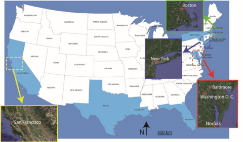
Description: U.S. coasts feature a number of bays and estuaries within which many metropolitan cities are located: Washington, D.C. near Chesapeake Bay, New York City on the Hudson River, Boston on Massachusetts Bay, and San Francisco on San Francisco Bay, just to name a few. The impacts of storms and sea level rise on estuaries and bays are just beginning to be understood, and many questions remain unanswered. The semi-enclosed nature of bays also brings a unique set of challenges and opportunities for developing engineering or nature-based solutions to protect coastal infrastructure and communities. Natural habitats, such as salt marshes, oyster reefs, and sand dunes, offer coastal protection with ecosystem benefits, but the effectiveness and environmental impacts of these structures are not well understood. A shared network of waterways connects the diverse population of a basin, from urban population centers to rural communities, presenting new challenges linking socio-economic disparities and environmental factors. This National Science Foundation’s Coasts and People (CoPe), Research Coordination Network (RCN) will synthesize insights from existing coastal resiliency projects around the country and propose bold new strategies that integrate ecosystem enhancement and recovery to protect coastal communities and infrastructure. It will provide interdisciplinary training to young scientists through workshops and focus-group interactions. The RCN will have strong outreach activities through engagement with stakeholders in federal, state, and local governments; not-for-profit organizations; and coastal communities. The goal is to translate research results into specific recommendations for developing coastal resiliency solutions and seek stakeholders' feedback to orient academic research towards addressing pressing concerns faced by urban and rural communities living around the Nation's estuaries and bays.
Participating Institutions: University of Maryland Center for Environmental Science; University of Maryland, College Park; University of California, Berkeley; University of California, Davis; Stevens Institute of Technology; Woods Hole Oceanographic Institution; University of Massachusetts, Dartmouth; California Polytechnic University, San Luis Obispo.
Funding Source: National Science Foundation
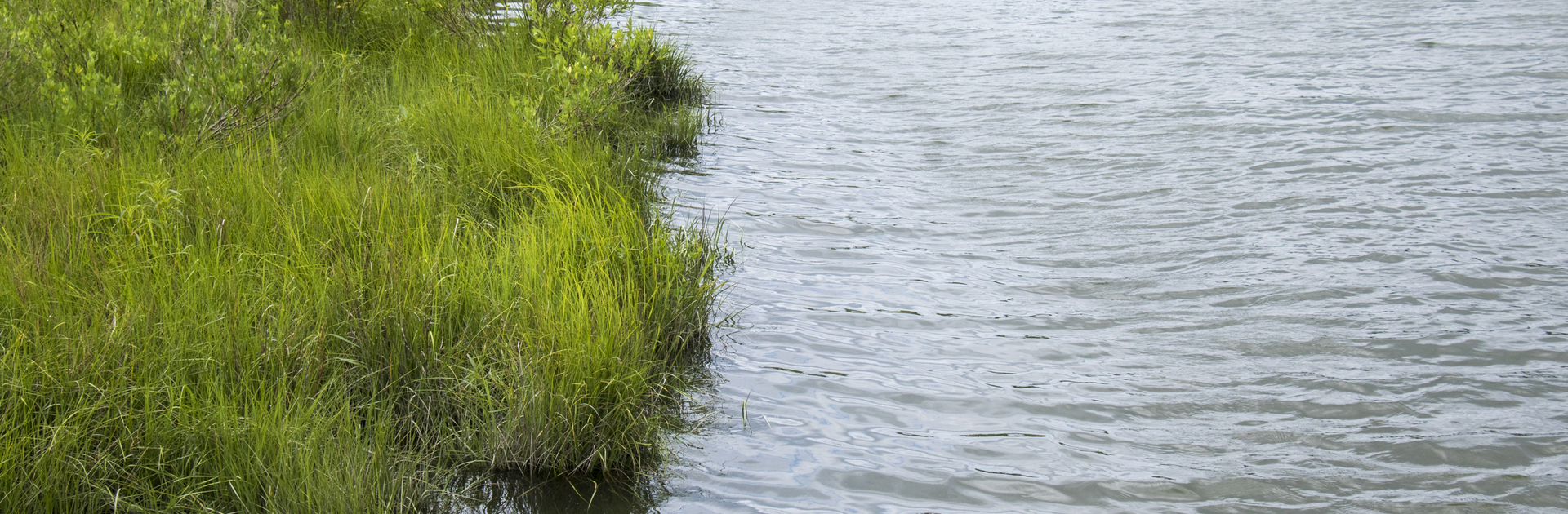
Assessing shoreline erosion and sediment deposition as contrasting influences on the sustainability of natural marshes and living shoreline
UMCES Faculty: Cindy Palinkas and William Nardin
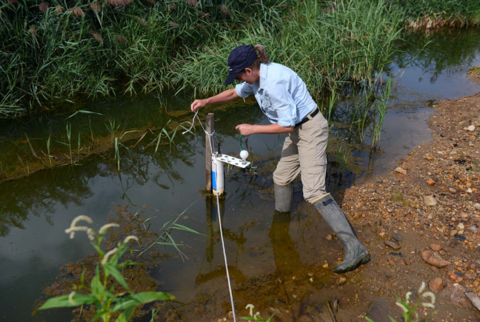
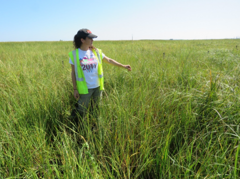
Description: The goal of this project is to evaluate whether the tools and metrics used to determine the vulnerability of natural salt marshes to environmental change can be applied to the created marshes of living shorelines (marsh fringes with or without additional structures). In doing so, we focus on 2 main questions, emphasizing the latter: 1) what factors influence shoreline erosion, sediment delivery and deposition in marsh-estuarine systems; and 2) what is the influence of living shorelines on these processes. We also address questions regarding robust indicators of saltmarsh trajectory. These are key open questions that are highly relevant to federal, state, and private land managers. Living shorelines have gained traction as the preferred approach to shoreline management in response to increasing shoreline erosion from human and environmental changes. Created marshes provide many of the same ecosystem benefits as natural marshes (e.g. nutrient burial and habitat for a variety of species) but are subject to the same stressors as natural marshes. While plant communities in created marshes are similar to those in natural marshes after a few growing seasons, other characteristics may take decades to approach equivalency. This begs the question of whether the same model can represent processes in living shorelines from installation onward, or if refinements are necessary as the created marsh ages. Our research takes place in Chincoteague Bay at living shorelines from 0-10 years old, integrating field and model results to test whether living shorelines follow expectations from natural systems as they age. Insights from this project are critical for assessing potential vulnerability of living shorelines to environmental changes over time to prioritize them for action.
Funding Source: U.S. Coastal Research Program (USCRP)
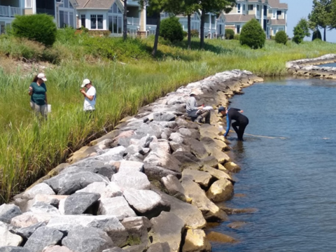
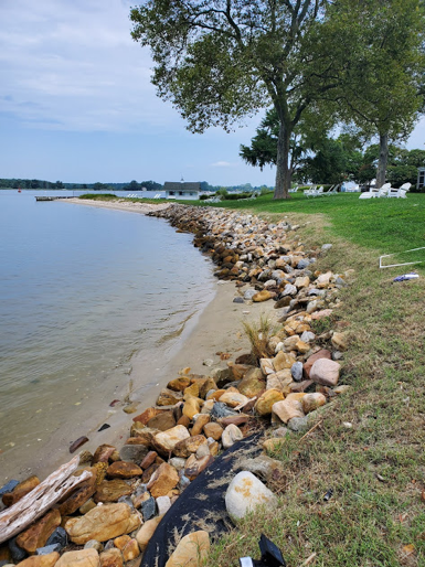
Oyster Veneers: A model approach to greening grey infrastructure
UMCES Faculty: Matt Gray, William Nardin, and Jeff Cornwell
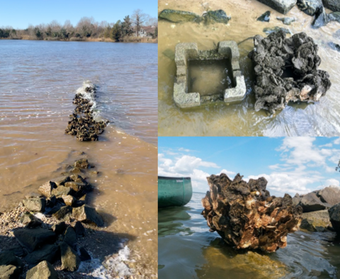
Description: Sea-level rise is rapid in the Chesapeake Bay and its impacts are especially pronounced along the eastern shore (e.g., Talbot and Dorchester Counties) due to low elevations, the proximity of towns to high-risk flooding areas, the broad socio-economic spectrum that includes many low-income neighborhoods, and the economic reliance on natural resources. Coastal infrastructure protects these communities from increased inundation and shoreline erosion. Otherwise known as “shoreline armoring,” the use of these grey shoreline stabilization features degrades the surrounding aquatic habitat, possess low habitat value and biodiversity, eliminate natural defenses against weather and climate-related impacts, and can be less resilient to coastal storms than nature-based green techniques like living shorelines. There are copious amounts of armoring (~1000 miles) along the shores of the Chesapeake Bay; however, without considerable updates and modification some arming, such as breakwaters, will be particularly vulnerable to sea-level rise.
We have been modeling and conducting field studies of how retrofitting oysters to existing breakwaters, called oyster veneers, can improve their long-term effectiveness long after these structures drown due to sea-level rise. Our approach has been focused on using oyster castles, which have been frequently in oyster restoration and living shoreline projects for the past decade in the mid-Atlantic. Aside from shoreline protection, we have been examining the water quality and habitat quality benefits that accompany introduction of oyster castles to habitat-poor grey infrastructure.
Funding Source: U.S. National Fish and Wildlife Foundation
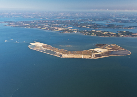
Paul S. Sarbanes ecosystem restoration project at Poplar Island wetland monitoring program: studies to address sustainability in the Poplar Island marshes
UMCES Faculty: Lorie Staver, Jeff Cornwell, Court Stevenson, William Nardin
UMCES Students: Daniella Hanacek
Description: UMCES has been involved in the restoration of remote island habitat at Poplar Island since the project planning stages in the mid-1990s. The project, supported by MDOT MPA and the U. S. Army Corps of Engineers, is a placement site for dredged material from the upper Chesapeake Bay, as well as providing a beneficial use through habitat restoration. Beginning in 2003, UMCES has been involved in monitoring sediment and vegetation development in the Poplar Island marshes, as well as targeted studies including assessments of marsh accretion and migration, developing nutrient and carbon budgets, geomorphological studies, and evaluating marsh establishment and management practices. In addition, UMCES faculty play an advisory role as members of a number of subgroups, including the Adaptive Management Team, Habitat Subgroup, Monitoring Subgroup and Upland Development Team.
Funding Source: Maryland Department of Transportation Maryland Port Administration (MDOT MPA) funding through Maryland Environmental Service (MES)
Hart-Miller Island pond issues and potential for biologically-assisted acid neutralization
UMCES Faculty: Lorie Staver, Jeff Cornwell, Court Stevenson
Description: The Hart-Miller Island (HMI) project is a placement site for dredged material from the Upper Chesapeake Bay. While the project resembles the Poplar Island restoration project in some respects, the wetlands are non-tidal and present challenges for restoration due to the biogeochemistry of the acid-sulfate soils. UMCES participation in the project has involved sediment and vegetation characterization, evaluation of wetland plant species for wetland restoration, and an advisory role for future plans for water quality enhancement and ecological aspects of habitat development.
Funding Source: Maryland Department of Transportation Maryland Port Administration (MDOT MPA) funding through Maryland Environmental Service (MES)
Developing composite time series restoration trajectories in salt marsh habitat in east coast sites
UMCES Faculty: Lorie Staver, Jeff Cornwell
Description: This project will use Poplar Island as a case study to develop guidelines for the beneficial use of dredged material for tidal marsh restoration. Working with partners at USACE ERDC, UMCES faculty will analyze long-term monitoring data from older individual tidal marshes, as well as conduct a space for time analysis of data from marshes ranging in age from 2 to 15 years, to characterize development trajectories in tidal marshes constructed with dredged material at Poplar Island. Data from additional east coast beneficial use marsh restoration sites will be added following the Poplar Island data analysis, with the goal of formulating guidelines for beneficial use that will result in optimally resilient marshes and realistic expectations.
Funding Source: U.S. Army Corps of Engineers, Environmental Research and Development Center (USACE, ERDC)
Chesapeake Bay Sentinel Site Cooperative (CBSSC)
UMCES Faculty: Lorie Staver, Lora Harris, Cindy Palinkas, Court Stevenson
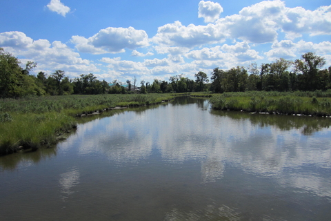
Description: The Chesapeake Bay Sentinel Site Cooperative (CBSSC), one of five cooperatives throughout the country, is funded by the National Oceanic and Atmospheric Administration (NOAA) National Sea Grant Office and state Sea Grant programs, to bring together scientists conducting individual long term monitoring programs at coastal study sites (i.e. “sentinel sites), particularly tidal marshes. The mission of CBSSC is to “integrate science findings from local observations across the [Chesapeake Bay] region to improve planning and management decisions regarding sea level rise and ecological changes.” By combining efforts, the cooperative, in partnership with coastal managers, decision makers and community liaisons, is helping communities in the region prepare for coastal flooding and other effects resulting from changing climate conditions.
Funding Source: NOAA, Maryland Sea Grant
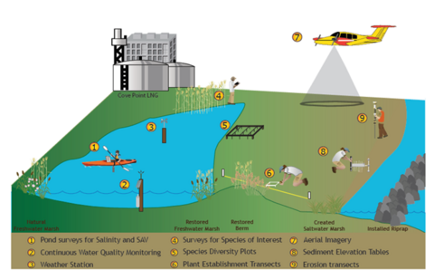
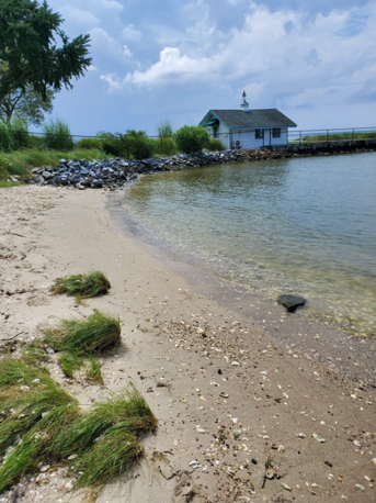
Cove Point marsh restoration and monitoring project
UMCES Faculty: Lora Harris
Description: Effective management of our coastal resources and communities requires improvements in understanding and monitoring our coastal ecosystems, especially our coastal wetlands. The Cove Point Marsh is situated on a bicuspate spit on the western shore of the Chesapeake Bay, creating an unusual condition where freshwater wetland conditions prevail adjacent to mesohaline estuarine waters. The prevalence of rare, threatened, and endangered species in this marsh resulted in its designation as a Maryland Natural Heritage Area. In 2006 a storm created a breach in the dune separating the Cove Point Marsh from the Chesapeake Bay, allowing salt water to flood the marsh and converting much of it to open water. In 2010 and 2011, Dominion Energy used dredged material resulting from a pier expansion project to repair the breach while also creating hard and soft erosion protection structures in front of the new dune. The Harris Lab has been monitoring the site since 2010, tracking the following metrics to assess the success of the restoration project: Changes in salinity and water quality of the freshwater marsh; Dune slope and beach width; Analysis of aerial imagery documenting wetland coverage; Vegetation community structure; Platform elevation; Establishment of plantings; Invasive species presence.
Funding Source: Dominion Energy Cove Point
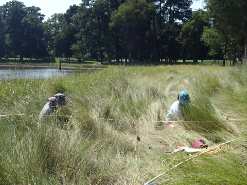
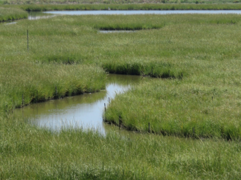
Toward more sustainable living shorelines: assessing long-term changes in living shorelines and nearshore SAV habitat
UMCES Faculty: Cindy Palinkas, Lorie Staver
Students: Miles Bolton
Description: This project focuses on living shorelines, potential changes in their effectiveness over time, and how they may change adjacent habitat for submersed aquatic vegetation (SAV). In partnership with managers at state agencies, practitioners, and non-profits, we have selected four ~2-year-old living shorelines near ~10-year-old living shorelines sampled with funding from the Chesapeake Bay Trust (CBT), so that changes during the lifetime of living shorelines can be examined. Our research addresses two key questions facing resource managers and property owners when considering living shoreline installation: 1) How we can promote living shoreline sustainability? And 2) How do they impact adjacent submersed aquatic vegetation (SAV) beds? We address these questions via sediment cores and plant surveys in the created marshes of the living shorelines and in adjacent shallow waters. Revisiting these sites every year is key for disentangling weather variability from living shoreline performance. In doing so, we have developed relationships with property owners to help not only with access but also insights into shoreline history before and after installation.
Funding Source: Grayce B Kerr Fund
Long-term impacts of living shorelines to SAV habitats in Chesapeake Bay
UMCES Faculty: Cindy Palinkas, Lorie Staver
UCMES Students: Miles Bolton
Project Description: This project evaluates potential impacts of living shorelines to adjacent submersed aquatic vegetation (SAV) habitat. Living shorelines, narrow marsh fringes with or without additional structures, are encouraged by legislation in many states, including Maryland. They provide similar ecosystem services as natural marshes (e.g., sediment and nutrient retention, wave attenuation) but are subject to the same stressors. Questions remain regarding living shoreline resilience to environmental change, especially in regions like Chesapeake Bay where relatively rapid rates of relative sea-level rise and declining sediment supplies have led to widespread marsh loss. Questions also remain regarding the potential long-term impacts of living shorelines to adjacent submersed aquatic vegetation (SAV), which are keystone species in Chesapeake Bay. The proposed project specifically targets these questions of long-term performance and impact of living shorelines by collecting sediment cores and plant surveys at eight ~10-year-old living shorelines and eight nearby unaltered shorelines. Project insights help inform management decisions on permitting living shorelines in areas with SAV on a similar time scale as that required for living shorelines to achieve functional equivalency with natural marshes.
Funding Source: Chesapeake Bay Trust
Resiliency through restoration
UMCES Faculty: Cindy Palinkas, Lorie Staver
Description: This project supports Maryland Department of Natural Resources’ Resiliency through Restoration (RtR) initiative (https://dnr.maryland.gov/ccs/Pages/Resiliency-through-Restoration.aspx), which supports on-the-ground implementation of nature-based projects. This project supports field work at three RtR sites with new living shoreline installations to inform adaptive management of nature-based practices. Through this project, we provide needed capacity support to collect pre-construction data on sediment and plant characteristics for comparison with post-construction conditions.
Funding Source: Maryland Department of Natural Resources
A model approach to ecological and community resilience in Oxford, MD
UMCES Faculty: Cindy Palinkas, Lorie Staver
Description: This project evaluates the performance of the living shoreline installed by the Town of Oxford as part of Maryland Department of Natural Resource’s Resiliency through Restoration (RtR) program over its first two years. Opportunities to collect physical and biological data before and after construction of living shorelines are very rare and provide valuable information for the improvement of restoration science. This project benefits the academic community, managers, restoration practitioners, and the town of Oxford. This innovative resiliency project will be showcased nationally to promote implementation of natural and nature-based solutions to shoreline erosion and rising sea levels, and the data we collect will be integrated with data from similar sites to maximize their utility.
Funding Source: National Wildlife Foundation